Farmers often use SSURGO soil type data to assign seed
rates. Their main assumption relates to
water holding capacity and organic matter as these macro soil attributes greatly influence ability to support higher populations. However there are some limitations to this public data set. They blame various things,
mostly related to resolution (aka "the darn lines are in the wrong place.")
When frustrated, farmers sometimes ask for normalized historic
yield maps to improve or replace SSURGO data.
However, when we’ve done this we often encounter resistance when they
finally get to the field. Why? Because it ends up assigning low rates to
“good soil” that they have tiled or otherwise improved. Often times the yield data has problems, like
switching varieties, missing data in middle of a field or only a few years of
“good data.” We can over exaggerate underlying soils rates but all this adds up to
conceptually liking the idea but practically avoiding it given lots of poor quality yield data. Can you say, tail wagging the dog?!
A long time goal of ours was to better describe predicted
soil moisture using slope. Despite the ease at which one can look and
perceive slope from an elevation map it is quite challenging to mathematically
capture it in most existing GIS software.
Well, we finally accomplished just that… both max-grade and position on
hill… top or bottom portion of the hill itself.

Above is a corn yield map from drought stricken
2012 field. As you can clearly see, the
yields don’t change exactly with the specific soil type zones change. However, it's decent, albeit, not perfect. Where "off", is that because they are wrong or because a B
slope soil type is simply too great a generalization for this application? Said another way, B slope simply means gently
rolling, but doesn’t say “this is a hill top.”
Sometimes it is, but often it has hill tops and valleys both, which
yield differently. Given the tabular data quality of the SSURGO
maps (and their ease of retrieval,) we’re not convinced we should abandon them just yet. Instead, how about we improve it?
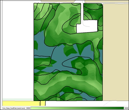
Below is a VR seed map for corn with original SSURGO map overlaid. You can see how the slope
extends the normal zone rates across various soil types. To accomplish this we started with a VR-Seed
map based on soil type and then used some logarithmic math to distribute based
on a proprietary slope algorithm. The
lower position in the hill (at same slope) gets more seed than does the same
slope toward the hill top. In fact, the
math effectively describes the concave or convex proprieties of all “hills and
valleys” at the given 100 ft square resolution.
Additionally, this VR-Seed file means that the farmer won’t
have those hard polygon transitions while traversing the field. In fact, the rates will gradually shift
higher or lower as he transitions between soils and varying slopes. Same soil type but in a valley? No problem… we’ll drop more seed. Same soil but on the top of the hill? No problem, we are dialing back. This elevation influenced data is able to be
accomplished even with WAAS data because of the relative nature of slope
position and 100 ft horizontal resolution. The ultimate result is a refined seed rate without
a crop consultant even visiting the field.

The final map is our proposed VR-Seed map for soybeans. As you might notice we invert the rates to
lower population to prevent lodging in the appropriate positions in valley of high OM soil types. At this point, we believe a good
farmer could “trump” these maps with his knowledge about drainage, fertility or
other oddities not represented in these two data sets that make his soils
different than the underlying SSURGO properties. (or, subdivide his SSURGO using smart zone soil sampling first and then apply this slope logic afterward!)
Adapting to variable rate seeding, thus maximizing profitability, will continue to evolve. Refinements to the process, such as this (slope and available moistures influence), can only enhance that process.
ReplyDelete